


The East and West coasts are facing a “double whammy” of powerful storms Tuesday, with storm-battered California facing potentially “catastrophic” flooding as the Northeast braces for a powerful nor’easter, forecasters said.
A coastal low was expected to strengthen rapidly into a major nor’easter that will significantly impact the Northeast through Wednesday, the National Weather Service.
The weather service warned early Tuesday that rates of 2-3 inches plus per hour and strong winds were expected to make travel “dangerous to impossible.” It said the heavy-wet nature of the snow, combined with maximum wind gusts of 55 mph would also likely cause power outages and damage to trees.
By early Tuesday, travel was already being affected by severe weather, with a ground stop issued for Delta Air Lines at LaGuardia Airport until at least 6:30 a.m. ET due to snow and ice.
New York Gov. Kathy Hochul warned at a news conference on Monday that the storm could be “deadly” as she urged residents not to be complacent.
“We’re no strangers to snow here, but we also want to make sure that does not mean complacency sits in. That is our biggest fear,” she said. “This is one where we’re cautioning people that this could be deadly.”
The governor said the storm could also bring a “serious loss of power” as she urged New Yorks to stay at home Tuesday.
The governor declared a state of emergency that went into effect at 8 p.m. Monday for a string of counties, her office said.
Personnel and supplies were also deployed Monday to several regions expected to be impacted by the major storm.
Snowfall totals of 12 inches or higher were forecasted over swaths of New England and Upstate New York, with localized max totals of 24-30 inches possible, it said.
The National Grid said in a statement that its storm readiness team was “monitoring the weather forecast and preparing to ensure reliability of the energy delivery system” ahead of the nor’easter.
By Monday night, the nor’easter had brought heavy rain to Philadelphia as it moved up the East Coast. Five New Jersey counties were under a weather-related state of emergency, and as much as a foot of snow was expected along Pennsylvania’s I-80 corridor, according to the National Weather Service.
‘Lives and property’ at risk in California
In California, the National Weather Service warned that excessive rainfall over parts of the state’s central and southern areas could cause “severe, widespread flash flooding” that could imperil “lives and property.”
The warning came as a front extending from the Northern Rockies to Central California was expected to bring a wave of low pressure onshore over the Golden State on Tuesday, the weather service said.
The storm is expected to bring heavy rain to parts of California, while high-elevation areas face heavy snow. Oregon and the Great Basin are also expected to see heavy precipitation, it said.
The severe weather could create considerable to “locally catastrophic flooding impacts” for parts of California as it shifts south across much of the California Coast, Central Valley and the Sierra Nevada foothills, the weather service said.
“Heavy rain, combined with snowmelt in terrain below 5,000 feet to result in more widespread flooding from Tuesday into Wednesday, particularly in low elevations and areas with shallow snowpack,” the weather service said.
“Heavy rain absorbed into the particularly deep snowpack in the Sierra Nevada, along with heavy snow, measuring in feet above about 7,500 feet, will further compound ongoing snow load impacts and issues,” the weather service said.
The weather service’s Weather Prediction Center issued a High Risk of excessive rainfall over parts of Central/Southern California through Wednesday morning in preparation for the storm’s impact.
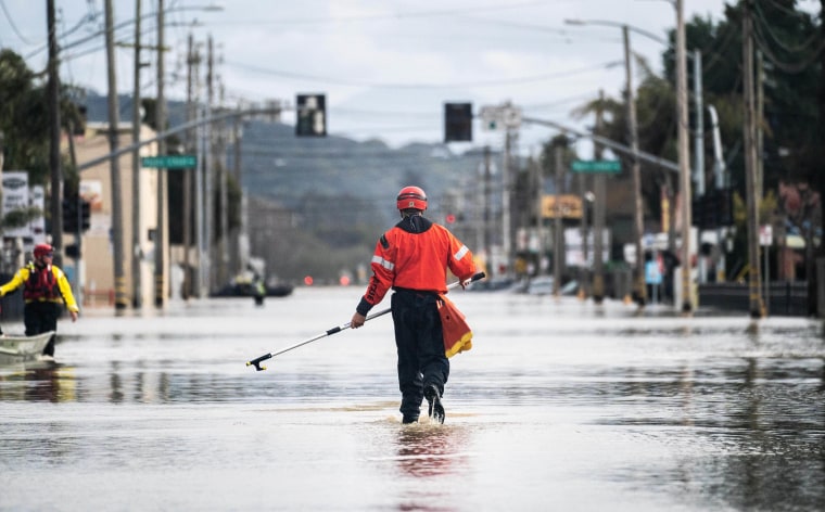
“Areas that normally do not experience flash flooding will flood,” the weather service said, warning that “lives and property are in great danger from Tuesday into Wednesday.”
A National Weather Service forecast discussion covering the San Francisco Bay Area from Monday night through Tuesday said, “Strong damaging winds, power outages, additional flooding, and road closures are all anticipated.”
“Avoid unnecessary travel and complete all preparations as soon as possible,” it said.
The threat of excessive rainfall was expected to decrease Wednesday to a Marginal Risk over parts of Southern California and the Southwest through Thursday morning, the National Weather Service said.
California grappling with streak of storms
The fresh round of severe weather comes following major flooding and severe winds over the weekend.
More than 200 people in lowlands north of Salinas have been rescued by first responders, including members of the California National Guard, authorities said at a news conference Monday, with one video showing a member of the Guard helping a driver out of a car trapped by water.
Monterey County, a national agricultural center, was hit hard by the weekend storm, with an estimated 2,000 residents of the town of Pajaro under evacuation orders after a 300-foot breach in an adjacent river levee started opening up early Saturday, officials said.
A second, smaller breach near the mouth of the river took place was reported Monday, said Maia Carroll, spokesperson for Monterey County. Officials believe this one may be beneficial.
“The water is flowing to the ocean and relieving upstream flooding,” she said.
Meanwhile, the National Weather Service in Sacramento on Monday confirmed that a tornado had touched down in the area of Tuttletown, about 50 miles west of Yosemite National Park, on Saturday. Forecasters said it was an EF-1 vortex, meaning it had sustained winds of at least 79 mph. Severe thunderstorms and hail had accompanied the tornado, the weather service said.